At the 2023 Las Vegas edition of IGNITE, after an evening of collaborating, networking, cocktails, and gambling (of course), product manager Joshua Martin continued to bring the Vegas energy with a deep dive into PropertyIntel—Aspire’s coolest measuring tool.
“PropertyIntel was designed to revolutionize how property measurements are taken by making measuring properties of any size and shape easier, faster, and more accurate. It utilizes cutting-edge technology to ensure highly accurate measurements, eliminating the need for manual calculations or estimations,” Martin said.
He went further into the significant benefits of PropertyIntel for customers:
“PropertyIntel helps landscape companies seamlessly collect, connect, and visualize essential data to drive new profitability and performance levels,” Martin said.
PropertyIntel can help your business thrive. Dive deeper with a free trial today.
Collect accurate data
Get the measurements you need with precision measuring tools, hi-res aerial imagery, and PDF uploads.
Connect related data
Bridge the property and customer data gap with automated data insights, reporting, and optimization suggestions.
Visualize essential data
Gain greater clarity into your business with visual, interactive sitemaps and reporting dashboards.
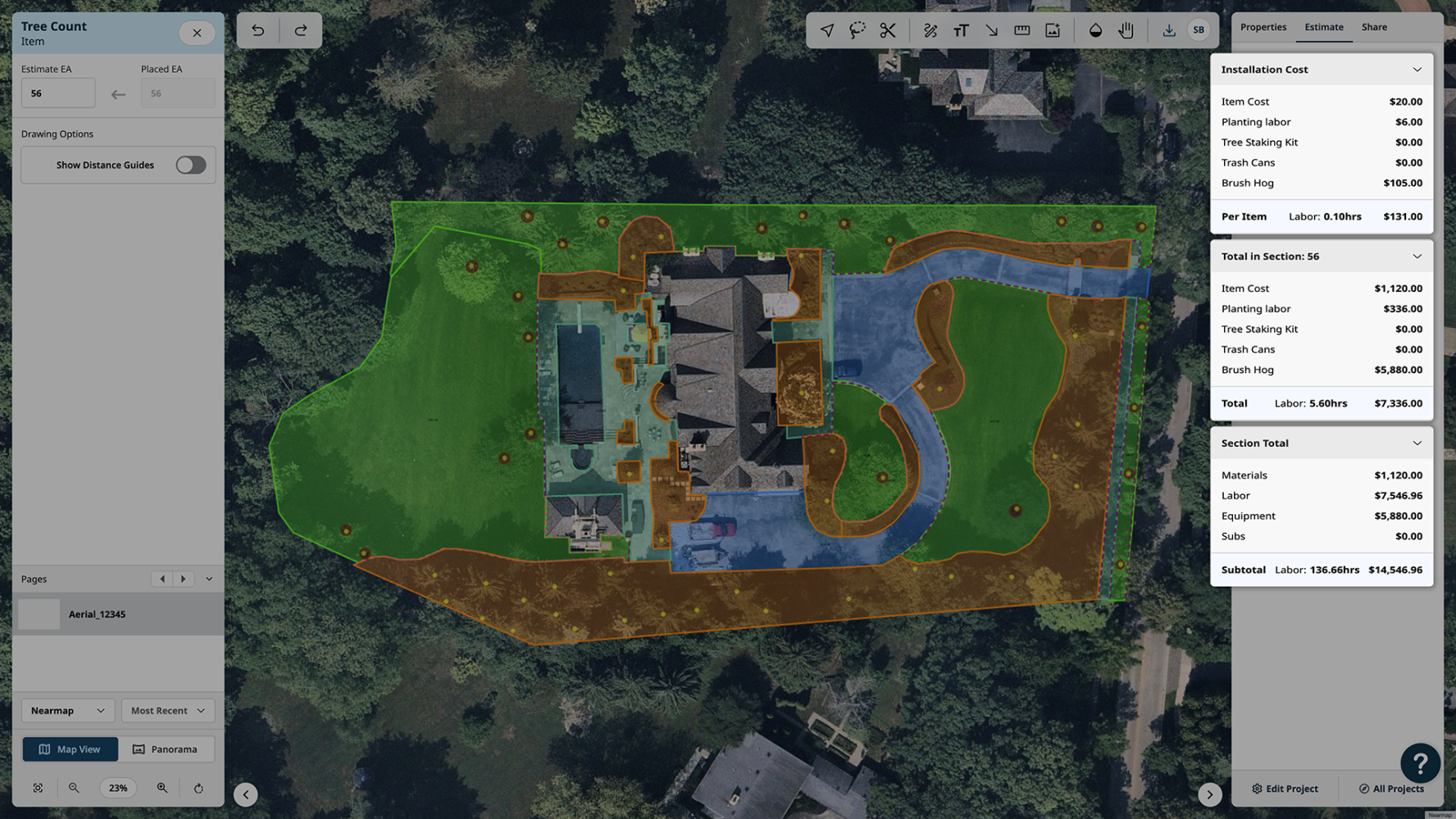
Martin elaborated on particular use cases with stunning product imagery:
Residential and Commercial Maintenance
PropertyIntel uses high-resolution aerial imagery and PDF uploads to create fast, professional takeoffs. You can collect all the site data you need, sync with your Aspire property, and keep all your contracts and renewals up to date and accurate. Use color-coded maps and plans to stand out from your competitors and win more jobs.
Snow Maps
Use color, text, and arrows to delineate areas and equipment needs. Clearly show your team how to correctly service the property every time.
Enhancement Design
Proactively sell enhancements with easy, quick, and on-the-spot designs and instantly sync designs to Aspire Opportunities to price and propose. Next up? Hand off closed jobs to production with clear plans and designs.
Example: Annual Color Plan
Use PropertyIntel to make seasonal color change a breeze. Create plans and 2D designs of how beds should look and gather all your plant counts and material quantities. Export and share with customers so they can visualize their project plan.
However, according to Martin, collecting this data is merely the first step in standardizing your business processes. PropertyIntel extracts valuable data from property details, surveys, and environmental factors and syncs seamlessly with Aspire’s platform, where the real magic happens. Property and Opportunity Tags from Aspire sync to PropertyIntel, where Actual Values rather than Estimated Values are pushed to Aspire.
Martin concluded, “With a shared data environment like this, the options are endless!”
Create takeoffs for maintenance work, design-build projects, enhancement, and opportunities.
Use high-resolution aerial imagery and PDF uploads to create fast, professional takeoffs.
Calculate time, material, and cost estimates automatically as you measure with data imported from your pricing database.
Send visual proposals with pricing breakdowns, color-coded project sitemaps, and customizable cover letters in minutes.
PropertyIntel allows landscape contractors to create takeoffs for maintenance and design-build. Through direct integration with the Aspire platform, users can simultaneously automate data insights, reports, and optimization suggestions.
Users can also access and submit orders to PropertyIntel Complete—Aspire’s new automated measuring, estimating, and takeoff service. PropertyIntel Complete allows landscape contractors to provide property addresses and receive precision-measured takeoffs directly within their PropertyIntel account.
Ready for more Aspire news that will spark your business? IGNITE 2024 will pick up right where we left off—more learning, networking, and growing. Register now.


